Satellite Zhuhai Constellation
Zhuhai Constellation
“Zhuhai No.1” Remote Sensing Micro-Satellite Constellation The "Zhuhai No. 1" satellite constellation is planned to be consisted of 34 satellites, including 2 x 1.98m Video & Image satellites, 10 x 0.9m Video & Image satellites, 10 hyperspectral satellites, 2 high-resolution optical satellites, 2 SAR satellites and 8 infrareds satellites. After completion, it will have the following characteristics: global remote sensing, all-weather monitoring, all-day monitoring, high spatial resolution, high spectral resolution, and high time resolution. 2 Video & Image Sats (OVS-1, 1.98m/8.1Km) 10 Video & Image Sats (OVS-2, 0.9m/22.5Km) 10 Hyperspectral Sats (OHS, 10m/150Km) 2 High resolution Sats 2 SAR Sats 8 Infrared Sats
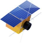
OVS-1 Video & Image satellite
Spatial resolution: 1.98m@530km
Weight: 50kg
Imaging range: Video 8.1km × 6.1km @ 530km
Image 8.1km × 6.1km @ 530km
Running track: 43° circular orbit, orbital height: 530km
Data transmission rate: 80Mbps
Imaging method: gaze(video) + strip(image)
Video frame rate: 20fps
Video duration: up to 90s
On-orbit life: better than 3 years
Acquire data: 2 satellites can acquire 58TB of data per year
Coverage capacity: 2 satellites can cover the earth once every 156 days, covering globally 2 times a year
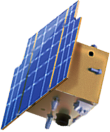
OVS-2 video&Image satellite
Spatial resolution: 0.9m@500km
Weight: 87kg
Imaging range: Video 4.5 km (1~5) × 2.7km@500m
Image 22.5km × 2500km @ 500km
Running track: 98° sun-synchronous orbit, orbital height: 500km
Data transmission rate: 300Mbps
Imaging method: gaze(video) + strip(image)
Video frame rate: 25fps
Video duration: up to 120s
On-orbit life: better than 5 years
Acquire data: 10 satellites can acquire 4PB of data per year
Coverage capacity: 10 satellites can cover the earth once every 12 days, covering globally 30 times a year
OHS hyperspectral satellite
Spatial resolution: 10m@500km
Image Width: 150km@500km
Weight: 68kg
SNR: better than 300
Running track: 98° sun-synchronous orbit, orbital height 500km
Bands:256(pick out 32)
Spectral resolution: 2.5nm
Imaging coverage: 150km × 2500km
Data transmission rate: 300Mbps
Spectral range: 400nm-1000nm
Calibration method: support on-orbit calibration
On-orbit life: better than 5 years
Acquire data: 10 satellites can acquire 6.5PB of data per year
Coverage capacity: 10 satellites can cover the earth once every 2 days, covering globally 182 times a year
Land-use/Land-cover Monitoring
Techniques of remote sensing, geography information system and global positioning system are applied to monitor national region in all weather conditions, to ensure the accuracy, integrity and update of land investigation, land use and land dynamic monitoring, thus achieving effective management of land resource.
Precision Agriculture Management
Agriculture information can be obtained by remote sensing satellite in nearly real-time, including crop categories and growing status, by analyzing remote sensing image data, which provides decision-making support for planting activities, pest control and production increase.
Water Resource Monitoring
Remote sensing technique is widely applied in disasters monitoring, evaluating of floods and drought, investigation of soil erosion, hydraulic engineering plan, ecological environment monitoring and river pollution monitoring. By taking advantages of satellite remote sensing, demands of water conservancy department can be met, which leads to Intelligent water conservancy.
Forestry resources management
With use of remote sensing technology, geographic information system and cloud-computing, datas can be effectively obtained in real-time and be used in daily management (including forest-fire prevention, deforestation, and statistics of forest resources, etc.), to provide technical support for resource monitoring and performance evaluation on ecological project, and to perform macro, dynamic, precise and continuous monitoring on national forestry area in all weather conditions.
Ocean Environmental Monitoring
Marine remote sensing is used to monitoring marine and coastal zones, with technical advantages of multi-temporal, multi-band, fast response and large area coverage. Marine remote sensing can be applied to marine environment and resources investigation, marine fishery dynamic monitoring, marine pollution measurement, marine disaster warning, coastal and island investigation, marine engineering management, marine surveying and mapping and route selection.
Environmental Protection Support
Remote sensing technique plays an important role in monitoring、 managing and control of environment pollution, including water and air pollution, by providing ecological data services to environmental protection administration departments and enterprises